A beautiful (and long) hike to the Koruldi Lakes
Tucked away in the rugged heart of the Caucasus Mountains, the Svaneti region in Georgia is renowned for its dramatic scenery, characterised by towering peaks, lush valleys, and glacial lakes, creating a stunning backdrop for some excellent hikes, and opportunities to take amazing panoramic photographs. The Svaneti region is still relatively unexplored, as its remoteness has made it challenging to access. However recently built roads, have started to open up the location to everyone, including those with poor mobility.
There are lots of beautiful hikes leaving from both Mestia and Ushguli, and hiking enthusiasts will typically spend a week or so in order to fully explore. The hikes tend to take a full day each, and some can be quite difficult with rough terrain and steep elevation. There are also some quicker but more difficult shortcuts that can be taken, and nowadays you can also cheat and take a car some or all of the way.
The best time to visit Svaneti is from late spring to early autumn (May to October) for hiking and exploring.
I have other posts covering more about the region, other hikes, and some logistical information that you can easily access through the links below, however this post is focused on one of my favourite hikes in Svaneti - the hike from the centre of Mestia to the Koruldi Lakes. This scenic trek offers breathtaking panoramic views of the Caucasus Mountains, including the majestic peaks of Ushba and Tetnuldi.
The trail, rich with diverse flora and fauna, leads adventurers through lush alpine meadows and rugged terrains, culminating in the serene beauty of the pristine Koruldi Lakes. Perfect for nature lovers and hiking enthusiasts, this hike is a must-do experience that showcases the unparalleled natural beauty of Georgia's Svaneti region.


Disclaimer
This hike is really tough, with almost 1500m elevation gain (and then 1500m loss on the way back), some very steep bits, and uneven terrain that requires proper hiking shoes. The return journey is ~22km from Mestia and it took us around 8 hours including quite a few stops along the way. Strava told me we were actively hiking for closer to 6 hours, but we went at quite a pace, and were constantly overtaking people. If you want to take it more leisurely, I would budget 8-9 hours. Many people were shocked when we told them we had hiked the whole way. However, the views are beautiful on the way and I have no regrets (even if my feet may have disagreed…).
Top Tips:
You can shorten the hike with a jeep taxi to the cross (cutting the hiking time to ~3-4 hours), or even now all the way to the top, if you are short on time or keen on just seeing the lakes themselves. Any of the little offices or “bus stations” in the centre of Mestia will offer these journeys, though it isn’t cheap…
You don’t need to hire a guide to the lakes as the path is mostly quite obvious and this guide will tell you all you need to know to be able to follow the route. However, for some of the other hikes after the lakes, you might consider a guide.
There are two cafes on the way up. These are a lifesaver, particularly in the summer when a cold drink feels amazing. One is just after the cross (around halfway), and the other is about an hour’s walk later, just before you do the last push to get to the lakes. We stopped in the second one, and the woman who worked there was so friendly and kind. The prices were reasonable, and she even gave me a free cucumber! The cafe by the cross was closed when we went, so make sure you take enough water with you so that you aren’t completely reliant on the cafes.
Check the weather forecast! The weather in the mountains can be quite unpredictable, and there are not many places for shelter along the way (either shade nor from rain). Take a backpack with sun protection, a rain jacket, and enough snacks / water for the journey. This hike should only be attempted in the summer months, our guesthouse told us that even doing this in May can be sometimes too slippy and icy and therefore not advised. Similarly, I believe the jeeps don’t go up there in the winter.
Start early. It gets incredibly hot, and sunny from around 11am onwards. You will really thank yourself for avoiding the peak sun as much as possible during the ascent.
Camping is an option if you want to catch the sunset / sunrise. A few people we spoke to had camped overnight at the lakes and hiked back down the following morning. We didn’t do this, but heard that it was beautiful, so if you have time and camping gear, it might be something to consider!
Avoid the “shortcuts”. There are some “shortcuts” you might read about in other older blogs. We bumped into a few (very fit and well equipped) people who had tried one of these and they told us they were absolutely awful to take and were so steep they required climbing using their hands at points, with slippy rocks beneath their feet that they felt were dangerous. If you are feeling adventurous, then go for it, but we were heavily advised against it.
Now that you are prepared for the hike… let’s begin!
The Route itself
The route is not particularly well marked, and there are sometimes multiple paths you can take which can be a bit confusing - particularly when you go through the trees. I would suggest taking a screenshot of my strava route, and tracking your route on strava too so you can compare to ensure you are vaguely on the right track.
One of the most confusing bits is leaving Mestia, so I have zoomed so you can see the path and compare to your own maps.


The trail begins from the town of Mestia and follows up the streets from Seti Square. Walk along the main road until you are at the edge of the town, and then turn left. There is a steep paved road to follow up, past several svan tower houses and through a stone arch. Keep going up this road, which becomes more of a dirt path, until eventually it leads you onto a rocky trail and off into the forest.
We somehow picked up a cute dog with us as we left the town, who followed us and then proceeded to lead us the whole way up to the lakes, and back down. He would often run ahead and then wait for us in the shade, ocassionally running back to make sure we were okay (and perhaps question why his humans were so slow), but I think he liked the company as much as we did, and we gave him some water along the way!


You wind through the forest for about an hour. At times, the path was quite narrow, but the forest part felt quite leisurely and it was nice to have some shade from the trees. You keep going along here until you get to the jeep track.
This part is easy to follow, as you just follow the road. There are also some bits of shade as it still is low enough that there are trees nearby. You will need to ocassionally move to one side to let jeeps past though. When there are gaps in the trees, you start to get glimpses of beautiful views of the mountain.


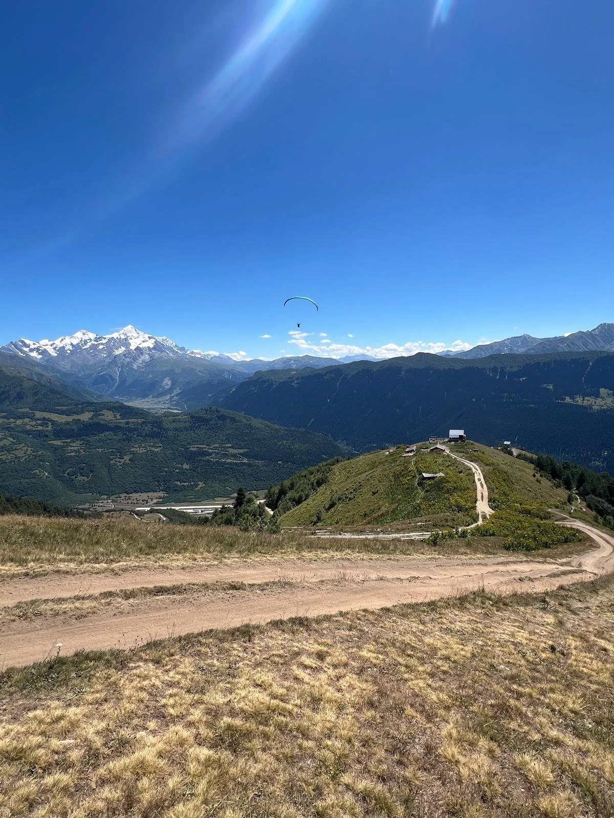
The jeep path leads you to the cross which has a nice viewpoint and is a good place to stop for a sip of water or a snack.
There is also a paragliding school nearby that takes off from close to the cross. We saw a few people and I’m sure it is an incredible experience, though you may want to do some proper diligence if it is something you are interested in, as we heard varying reports about the safety and practices.
From the cross it is a gradual climb up to the lakes on quite an obvious pathway. You will start to see more people here because lots of people take the jeep to the cross and hike up from there. You can stop for a drink or a bite to eat in one of the two cafes along the way (if they are open). Take your time going up, as it is quite steep and tiring, without any shade to cool you from the sun. You will be rewarded with some fantastic views the higher you get up, so make sure to enjoy the experience!


From the lakes you can continue up to the Guli Pass, or to the Koruldi ridge, though both of these are long hikes in themselves and normally require an overnight camp. Alternatively, you can take the jeep up to the lakes to save time so that you can continue onto other hikes from there.
For the return, you do the same journey in reverse. The journey down is much quicker and will take probably around 60% of the time it took you to get up there, however be warned, the last bit as you are going back into the village is the hardest, as it is quite steep on loose stones. Your legs will probably also be quite tired by then so take it easy! This is where our new best friend the dog also left us (likely as we were too slow for him).
Now get back to your guesthouse, or take a nice cold drink in one of the many cafes in Mestia! You’ve earned it!
Other posts you may be interested in:
Overview of the Svaneti region
Getting to Mestia
Day trips to Ushguli
Where to stay
Other day trips in the Svaneti region
Shkhara Glacier Hike
Chalaadi Glacier Hike
Mestia to Ushguli